Space particles
Space is not as empty as it might seem at first glance, especially near the Earth. The space environment of the Earth is very complex and is filled with particles of various energy and origins. Some of which constitute the radiative environment of the Earth.
The study of the effects of space radiation on the atmosphere is very important both for climate in the case of induced ionisation and for human safety in the case of induced radiation. For this matter, it is of great importance to understand both the dynamics of space radiations, and their effects on the atmosphere.
Using the Van Allen Probes and other satellite observations like PROBA-V, we studied the radiation belt boundaries and the auroral regions [1]. These auroras are generated by the precipitation of energetic particles coming from the plasmasheet in the terrestrial atmosphere and excite the constituents of the atmosphere. Auroras are generally located at higher latitudes than the outer radiation belt, but links are found especially during geomagnetic storms generated by solar events [2], when both boundaries move towards the equator.
Atmospheric simulations
As part of the EURAMET Biosphere project that kicked off in 2022, we aim to quantify both the ionisation and radiation dose rates throughout the atmosphere, by simulating various primary particles and spectra, replicating Galactic Cosmic Rays (GCRs), Solar Cosmic Rays (SCRs) and Radiation Belts particles (RBs) spectra.
The simulations are performed with the Atmospheric Radiation Interaction Simulator (AtRIS), based on the GEANT4 code developed by CERN. An important point of focus will be to investigate the evolution in time of the ionisation and radiation dose during important events, such as Solar Energetic Particles (SEP) events, or intense geomagnetic storms.
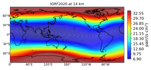
Considering rigidity cutoff values computed from the International Geomagnetic Reference Field (IGRF), preliminary simulations performed with only GCR protons during quiet conditions compare well with the literature:
- Maximum of ionisation (the Pfoltzer maximum) is located at around 12 km of altitude.
- The ionisation is always maximum at high geomagnetic latitudes, where the geomagnetic field lines cross the surface of the Earth and where the rigidity cutoff is almost null.
References
[1] Pierrard V., E. Botek, J.-F. Ripoll, S. A. Thaller, M. B. Moldwin, M. Ruohoniemi, G. Reeves (2021), Links of the plasmapause with other boundary layers of the magnetosphere: ionospheric convection, radiation belts boundaries, auroral oval, Frontiers in Astronomy and Space Sciences, 05, Coupled Feedback Mechanisms in the Magnetosphere-Ionosphere System, DOI: 10.3389/fspas.2021.728531.
[2] Rouillard A.P., Viall N., Vocks C., Wu Y., Pinto R., Lavarra M., Matteini L., Pierrard V., Sanchez-Diaz E., Alexandrova O., Lavraud B. (2021), The solar wind, Book Chapter in Solar Physics and Solar wind, AGU Monograph, ed. Nour-Eddine Raouafi and Angelos Vourlidas, Vol. 1, 1-33, DOI: 10.1002/9781119815600.ch1, ISBN: 978-1-119-50753-6, 320 pp.


